


Uganda ranks high for primate safaris and forest expeditions. However, the country’s hiking value and alpine peaks remain overlooked in most tourism strategies, despite offering remarkable ecological and technical value in Uganda and beyond.
Mount Elgon and the Rwenzori Mountains form the backbone of hiking and mountaineering in Uganda. Each represents a distinct geological story, climbing experience, and conservation framework.
Hiking these mountains in Uganda is not only physically rewarding. It also contributes to long-term sustainability efforts, supports local livelihoods, and generates research insights for climate and ecosystem monitoring.
You, the reader, may be weighing options, preparing an investment proposal, or simply seeking data. This guide will equip you with clarity, facts, and professional framing.
What do you value most in a mountain expedition? Your answer may lead you east, toward Elgon’s volcanic rim, or west to Rwenzori’s alpine glacier.
Either way, Uganda has altitude worth serious attention.
Geological Background and Formation
Mount Elgon and the Rwenzori Mountains in Uganda originate from entirely different geological events, and this difference shapes everything from their physical structure to their hiking conditions.
a. Mount Elgon: Volcanic Origins and Caldera Dynamics
Mount Elgon is an extinct stratovolcano located on the Uganda–Kenya border. Its formation began approximately 24 million years ago, making it among East Africa’s oldest highland systems.
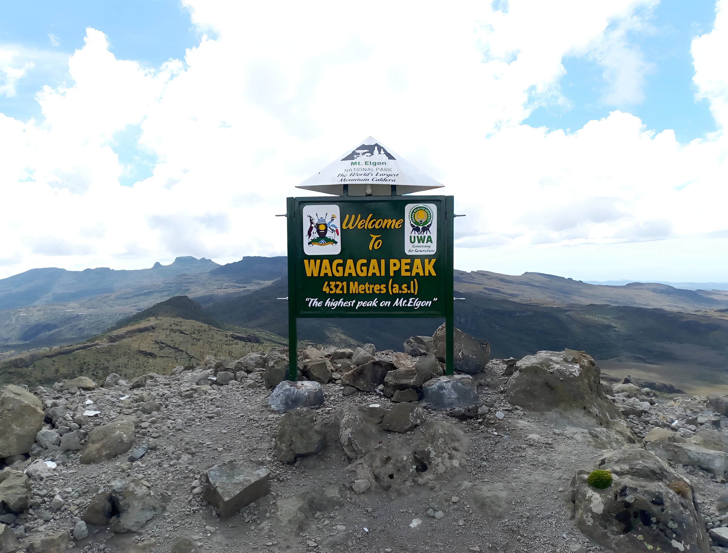
At its peak activity, Elgon rose higher than Mount Kilimanjaro. Erosion and tectonic shifts have since reduced its elevation to 4,321 meters at Wagagai Peak.
The mountain’s defining feature is its summit caldera. It spans over 40 square kilometres, with clearly defined rims and internal volcanic plugs such as Jackson’s and Mubiyi Peaks.
Geologically, Elgon is composed of alkaline lava, primarily phonolite and trachyte. These rock types weather into fertile soils that support endemic plant growth.
Besides the caldera, you’ll find radial valleys, secondary cones, and extensive lava plateaus. These geological traits influence trail layout and hydrology across the park.
In addition, Elgon lacks glaciation, which allows uninterrupted forest regeneration across its upper slopes. This shapes both the hiking environment and long-term ecological monitoring, unlike other peaks in Uganda.
You may not notice it at first glance, but every step on Elgon’s trails follows the contours of an ancient volcanic collapse.
b. Rwenzori Mountains: Tectonic Uplift and Glacial Legacy
The Rwenzori Mountains lie within the Albertine Rift Valley and form part of the western branch of the East African Rift System. Their formation began about three million years ago.
Unlike volcanic ranges, the Rwenzori emerged through tectonic block uplift. Massive faulting forced a slab of the Earth’s crust upward, creating peaks exceeding 5,000 meters.
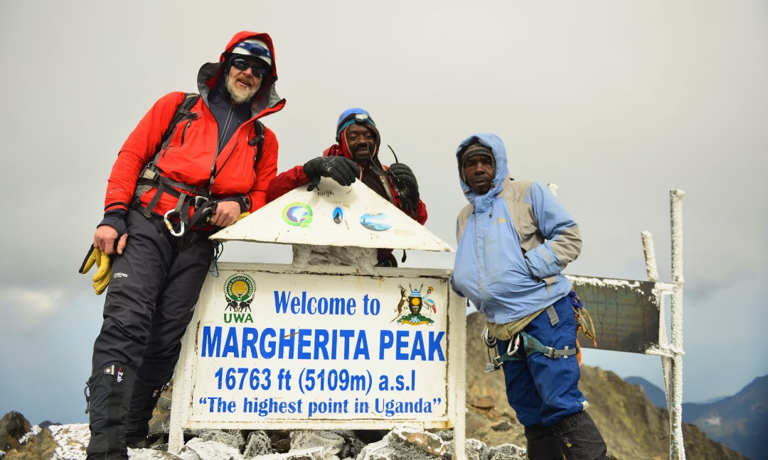
Margherita Peak, at 5,109 meters, stands as the highest point in Uganda. It rises from the Mount Stanley massif, one of six named massifs in the range.
Geologically, the range comprises ancient metamorphic rock—primarily gneiss and quartzite—with interbedded amphibolite and phyllite. These materials resist erosion, which helps preserve the steep alpine contours.
Besides uplift, glacial activity has reshaped the upper zones. Cirques, moraines, and U-shaped valleys testify to multiple glacial advances over the last 20,000 years.
Today, remnants of those glaciers persist on Margherita, Speke, and Baker Peaks. Although retreating, they continue to influence local hydrology and trail safety above 4,500 meters.
For trekkers, Rwenzori’s foundation is more than dramatic. It determines footing conditions, anchorage points for ropes, and even the placement of alpine camps.
Understanding these forces helps explain the Rwenzori’s vertical intensity and infrastructural complexity.
Location and Accessibility
Understanding the geographic placement and logistical accessibility of Uganda’s mountain ranges is central to both operational planning and tourist itinerary design.
Each mountain connects to distinct urban centres, transport networks, and park administration frameworks. While Mount Elgon aligns closely with Uganda’s eastern road systems, the Rwenzori Range occupies a more remote position along the western frontier.
The differences carry real implications for coordination, resupply, and route staging.
Read Also: UNESCO World Heritage Sites in Uganda
a. Mount Elgon: Easier Road Links and Border Position
Mount Elgon straddles the eastern edge of Uganda, with its foothills beginning near Mbale town. The nearest park entry point is Budadiri, 25 kilometres from Mbale.
The mountain is part of Mount Elgon National Park, jointly managed by Uganda Wildlife Authority and Kenya Wildlife Service. However, most visitors access it from the Ugandan side.
You can reach Mbale by road from Kampala in 4 to 5 hours. The journey passes through Jinja and Iganga, with sealed roads all the way.
Besides Budadiri, trailheads are found at Kapkwai near Sipi and at Kapkwata along the forested Piswa route. UWA stations offer orientation and ranger support at all points.
Mbale town provides basic resupply, medical support, banking services, and hotel accommodation. It’s also a staging area for equipment rentals and porter coordination.
In addition, Sipi Falls—a popular pre- or post-trek stop—lies just 15 kilometres from the Kapkwai trailhead. That makes it convenient for hybrid itineraries.
Park permits are processed directly at trailheads or online through UWA’s centralised system. For international tourists, the daily park fee is currently 50 USD per person.
If you prefer moderate elevations and easier logistics, Elgon’s location works in your favour.
b. Rwenzori Mountains: Western Edge, Alpine Complexity
The Rwenzori Mountains rise along Uganda’s western frontier with the Democratic Republic of Congo. The entire range falls within the Rwenzori Mountains National Park.
Most climbs begin from Kasese town, which is 6 to 7 hours by road from Kampala. The route passes through Fort Portal, a secondary staging hub.
The park’s main access points are Nyakalengija for the Central Circuit and Kilembe for the longer, technically demanding southern approach. Both are near Kasese airstrip.
Besides road travel, domestic flights by AeroLink Uganda connect Entebbe to Kasese three times a week. Flights take approximately 75 minutes and land 20 minutes from the trailheads.
Unlike Elgon, the Rwenzori requires a guided trekking company. Permits are bundled with logistics, guides, food, and accommodation through RMS or Rwenzori Trekking Services.
In addition, overnight huts must be booked in advance. Trail permits, porter coordination, and equipment transfers are arranged by the operator, not through UWA directly.
That said, you should review logistical constraints early. Supply chains are longer, and weather occasionally disrupts the porter’s movement between stations.
If you’re designing a multi-day ascent with technical elements, Rwenzori’s logistics demand deliberate coordination and a bit more lead time. It’s manageable—but not casual.
Altitude and Climbing Difficulty
Altitude defines not only a mountain’s physical challenge but also its climatic thresholds, acclimatisation needs, and technical classification. For both the Elgon and the Rwenzori Range, elevation gain influences everything from rescue planning to gear selection.
This section examines peak heights, gradient types, climbing durations, and physical demand through a strictly topographical and practical lens.
a. Mount Elgon: Moderate Elevation, Gradual Ascent
Mount Elgon reaches 4,321 meters at Wagagai Peak. Although high enough to require acclimatisation, its elevation gain occurs across extended distances with mild vertical gradients.
Climbs typically last 4 to 6 days, depending on the route. The Sasa Trail is the most direct, reaching the summit in as little as three days.
Besides Wagagai, secondary peaks like Jackson’s Summit and Mubiyi Peak offer optional ascents. None require ropework or advanced alpine gear.
The trails maintain a moderate incline. Daily elevation gain ranges between 500 to 900 meters, with most ascents beginning at around 1,200 meters in Budadiri.
In addition, Elgon’s wide caldera allows for dispersed trekking. Trail congestion is minimal, and altitude effects are generally manageable for fit individuals.
Acclimatisation is still important. Hikers are advised to ascend slowly and hydrate frequently, particularly on the third day.
If your objective is altitude exposure without technical climbing, Elgon provides consistent elevation gain with logistical simplicity.
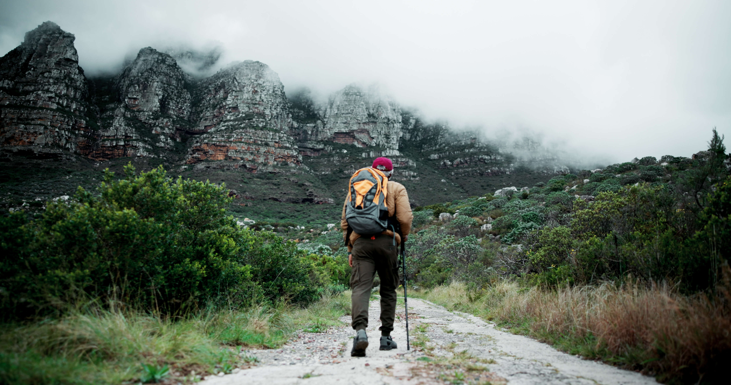
b. Rwenzori Mountains: High Altitude and Technical Demands
The Rwenzori Mountains reach 5,109 meters at Margherita Peak, which lies on Mount Stanley. This makes it the third-highest point in Africa by elevation.
Climbers require between 7 to 10 days for the full ascent and descent. The Central Circuit and Kilembe Trails involve high-altitude trekking above 4,000 meters for several days.
Besides altitude, the range includes technical zones. Ascents above Elena Hut involve snow, ice, and rock scrambling. Ropework is mandatory beyond this point.
Moreover, weather complexity intensifies the challenge. Frequent precipitation at altitude affects trail grip, visibility, and body temperature regulation.
Glacier crossings near the summit require crampons, ice axes, and trained guides. These technical sections are classified as Alpine Grade PD (Peu Difficile) under the French system.
Even experienced trekkers must adapt to variable oxygen levels. Daily elevation gain exceeds 1,000 meters on certain segments, especially between John Matte and Bujuku Huts.
You’ll need to prepare differently for this climb, mentally and logistically. Physical fitness is essential, but gear familiarity and altitude tolerance often determine summit success.
Scenery and Ecological Zones
Ecological zoning defines the character of each mountain and dictates what hikers, researchers, and planners encounter at every elevation band. These zones shape biodiversity, climate, and visual identity. Both Mount Elgon and the Rwenzori Range contain stratified environments with altitude-dependent transitions, each supporting a different blend of flora, soil type, and atmospheric conditions.
a. Mount Elgon: Open Caldera, Afro-Montane Mosaic
Mount Elgon’s vegetation zones range from tropical montane forest to Afro-alpine heathland. Most transitions occur between 1,200 and 4,000 meters in a clean vertical sequence.
The lower elevations are dominated by moist montane forest. These include species like Prunus africana, Croton macrostachyus, and wild banana. Bird activity is pronounced in this zone.
Above 2,400 meters, bamboo begins to dominate. Yushania alpina forms dense thickets, especially along the Sasa and Piswa routes during the second ascent day.
In addition, Elgon hosts a large zone of heather and giant lobelia from 3,000 meters upward. Lobelia telekii and Senecio elgonensis mark the Afro-alpine transition belt.
The summit caldera itself supports pockets of bog, exposed rock, and seasonal pools. Sedges and mosses dominate the inner floor, especially during wet months.
Moreover, the caldera rim offers uninterrupted panoramas of the surrounding farmland, often visible through breaks in the mist. The openness is visual, not metaphorical—it’s spatially literal.
If you’re documenting plant diversity or mapping ecological transitions, Elgon offers accessibility and broad visibility across its ecological bands.
b. Rwenzori Mountains: Glacial Valleys and Cloud Forest Stratification
The Rwenzori Range contains one of the most stratified ecological systems in equatorial Africa. Altitude, humidity, and slope angle govern sharp transitions between vegetation types.
The lowest zones begin at around 1,700 meters with moist evergreen forest. Podocarpus, Symphonia globulifera, and Newtonia buchananii dominate the Nyakalengija and Kilembe corridors.
Above 2,800 meters, the forest yields to bamboo and mixed montane woodland. Giant heathers and tree mosses mark the shift into zone three: the Afro-montane belt.
Moreover, the zone between 3,500 and 4,300 meters contains iconic Afro-alpine elements. Here you’ll see Lobelia wollastonii, Dendrosenecio adnivalis, and thick moss carpets on every surface.
Beyond 4,400 meters, vegetation thins. The alpine zone gives way to bare rock, glacial debris, and meltwater streams. This is where the silence starts to take over.
On top of that, glacial lakes such as Kitandara and Bujuku break the monotony of scree. They form catchments vital to downstream ecosystems.
The mountain’s high humidity keeps most zones cloaked in mist. This limits long-range views but deepens the sensory experience of passing from forest to glacier.
If your interest lies in high-altitude botany, watershed ecology, or vertical climate variation, Rwenzori presents a field laboratory with real research depth.
Climate and Best Time to Climb
Both Mount Elgon and the Rwenzori Mountains sit within the equatorial belt, yet their climbing windows differ due to altitude and local rainfall patterns.
Mount Elgon receives moderate rainfall, averaging between 1,200 and 2,000 millimetres annually. It’s the drier months that fall between June and August, and again from December to February. These periods offer more predictable hiking conditions and clearer summit views.
The Rwenzori Range, by contrast, is among the wettest mountain areas in Africa. Annual precipitation often exceeds 3,000 millimetres, with peak downpours in April, May, and late October.
High humidity and persistent mist define much of the trekking experience, particularly between 2,500 and 4,500 meters. Nonetheless, trekking is most feasible from late December through February and again from June to early August.
Besides rainfall, temperature fluctuation plays a role. Elgon’s lower altitude maintains milder night temperatures, usually between 6 and 10 degrees Celsius near the summit.
Rwenzori, however, drops well below freezing above Elena Hut. Snowfall is still present near Margherita Peak, despite ongoing glacial retreat.
In addition, weather volatility above 4,000 meters in the Rwenzori can delay ascents or require rerouting.
Climbers must remain flexible and allow contingency days when scheduling. If you’re building itineraries or preparing altitude-sensitive operations, this climatic rhythm should be factored into both safety protocols and guest expectations.
Cultural and Community Encounters
Mountain spaces in Uganda are not culturally neutral. They shape, and are shaped by, the lives of the people who live in their shadow.
Any serious consideration of Mount Elgon or the Rwenzori Mountains must account for the cultural presence, memory, and economic interdependence of surrounding communities. These aren’t merely peripheral villages.
They provide porters, interpretive knowledge, spiritual framing, and increasingly, structured tourism experiences. The following section outlines how human geography interacts with the physical environment.
a. Mount Elgon: Bagisu and Sebei Livelihoods
The communities surrounding Mount Elgon include the Bagisu to the south and the Sebei to the north. Both groups rely heavily on farming and forest-related livelihoods.
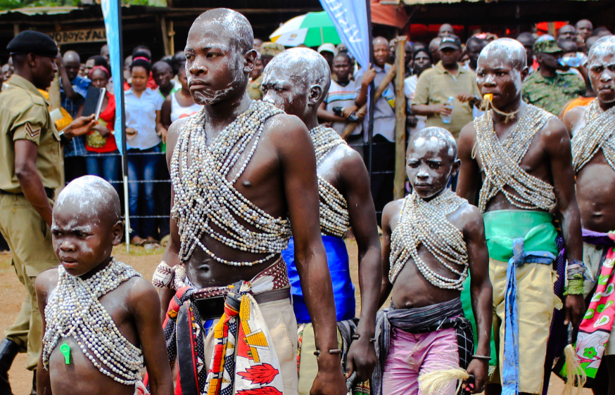
Cultural traditions are deeply linked to the mountain. Among the Bagisu, the Imbalu circumcision ritual marks male transition to adulthood and occurs every even-numbered year.
In addition, local legends tie Wagagai Peak to ancestral migration stories. These oral histories often appear in school syllabi and community-led tour briefings near Budadiri.
Tourists climbing through the Sasa Trail frequently pass through Bumasola and Budadiri villages. Here, local guides often double as cultural interpreters or storytellers.
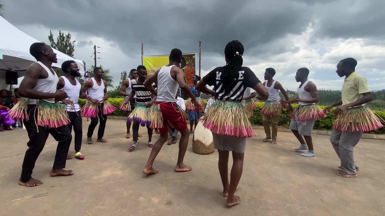
Moreover, homestay initiatives near Sipi and Kapchorwa now complement trekking circuits. Visitors join cooking sessions, brewing demonstrations, or agricultural tours, depending on seasonal availability.
If you’re assessing the mountain for cultural extensions or sustainable partnerships, the Mount Elgon foothills provide cooperative entry points with structured local governance.
Read Also: Choosing the Right Gorilla Trekking Operator
b. Rwenzori Mountains: Bakonzo Identity and Mountain Stewardship
The Bakonzo people inhabit much of the Rwenzori foothills. Their cultural identity is interwoven with the mountains, particularly through spiritual interpretations of mist, peaks, and water sources.
Traditional beliefs identify certain areas above 3,000 meters as sacred. Oral traditions describe the summits as resting places of ancestral spirits, often guarded by mythic figures.
Besides mythology, daily life revolves around banana farming, coffee cultivation, and small-scale livestock herding. These are visible along the lower circuit trails near Kyanjuki and Mihunga.
In addition, Rwenzori Trekking Services collaborates with local groups to manage porters, waste collection, and campsite maintenance. This approach strengthens long-term conservation through shared benefits.
Kikorongo Women’s Group and the Ruboni Community Camp offer cultural add-ons. These include dance performances, beekeeping sessions, and guided farm visits with interpretive commentary.
You may find that cultural exposure in the Rwenzori is quieter, more embedded. Yet it offers deeply grounded contact with community resilience and ecological responsibility.
Conclusion: Which Mountain is Right for You?
Both mountains serve different purposes depending on your priorities. Mount Elgon suits physically fit but non-technical climbers seeking a relatively accessible, scenic ascent.
Routes are shorter, infrastructure is simpler, and trail gradients are manageable. It is suitable for school groups, wellness retreats, and low-impact expedition models.
In addition, Elgon offers reliable conditions for photography, guided walks, and combined itineraries that include Sipi Falls or cultural circuits in Kapchorwa.
It’s also appropriate for testing altitude tolerance before attempting higher climbs elsewhere in East Africa.
The Rwenzori Mountains are better suited to experienced trekkers, technical mountaineers, and those designing high-elevation, multi-day programs. Glacial exposure, ropework, and equipment familiarity are essential near the upper sections.
Moreover, the range supports research-oriented climbs, specialist filming, and glacier monitoring assignments.
Clients with strong fitness, alpine ambition, or time flexibility will benefit most from a Rwenzori itinerary. Climbers with institutional backing or permit-driven objectives (such as altitude certification or biodiversity documentation) also align better with this destination.
If you’re evaluating the mountain’s suitability for a particular group, begin by reviewing skill level, logistics flexibility, and physical expectations.
Both ranges deliver value, but to different kinds of operations.